| The historic Rim of the World region. |
|
The region of the San Bernardino Mountains that our historical society
covers was first inhabited by Indians. During the warm summer�s months
in the valleys below, they would travel to our mountain areas for food,
hunting and relief from the heat. One of the early clans was the Serranos.
The San Manuel Band of Mission Indians is their descendents. The Mormons purchased a large parcel of land from the Lugo�s in 1851 that included parts of our local mountains. They built a wagon road up Waterman Canyon in 1852 to obtain timber for the construction of buildings in San Bernardino. Logging and cattle ranching were our early industries. It was not long until the natural beauty, weather and serenity of our area attracted vacationers and residents. Many early resorts, public and private clubs, places to eat and places to stay were soon built. It was also not long until Hollywood discovered our area because of our ever-changing scenery. They had fresh fallen snow in the winter and beautiful pines and pristine lakes in the spring and summer; and autumn colors in the fall. As a result, over 300 films have been �shot� in part or in whole in the San Bernardino Mountains. Waterman Canyon was named after Robert W. Waterman who owned a ranch there of several hundred acres. He was elected Lt. Governor in the election of 1886 and later became Governor on the death of Governor Bartlett in 1887 � he served until 1891. Waterman became well known as owner of the Waterman Mine near Barstow. In 1881 the Waterman post office was opened in this mining town. It closed in 1887 preferring the Barstow post office which opened a year earlier. The canyon was home to the Club Oaks, later Camp Sophia. Club Oaks dates to the 1930�s and provided dining, dancing, drinking and entertainment. There have been stories of the perhaps not-so-legal activities that took place there. Perhaps that is only �folklore�. Our local area includes five lakes: Lake Arrowhead, Lake Gregory, Green Valley Lake, Arrowbear Lake and Silverwood Lake. Recreational activities are abundant year-round. They include boating, fishing, hiking, swimming and both water and snow skiing. Click on images below to enlarge! |
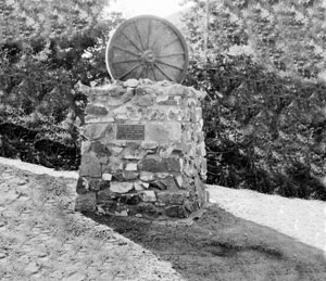 |
Mormon Monument. This monument, dedicated to the Mormons that built a road from the valley below to the mountain crest in 1852, is no longer standing. Dedicated in 1932 by the women of the �Thursday Club�, it honors the pioneer Mormon women of 1852. | |
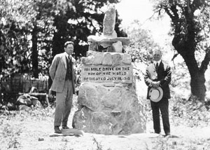 |
Original Rim Monument. Like the Mormon Monument, this monument dedicated in 1915 is also no longer standing. The occasion was the opening of the 101 Mile �Rim of the World Drive� on July 18, 1915. This new road connected the communities of San Bernardino and Redlands to the many mountain communities - including Crestline, Lake Arrowhead, Running Springs and Big Bear. | |
 |
Skyforest. This postcard image is captioned, �Forest Mercantile Co. Forest of the Sky, San Bernardino Mts.�. �Forest of the Sky� later became today�s �Skyforest�. The building pictured here was once located at the intersection of Kuffel Canyon and State Highway 18. The current building at this location was recently constructed. | |
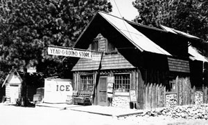 |
Twin Peaks. Pictured here is the now gone �Year O Round Store� in Twin Peaks. The store was once on State Highway 189 and was one of the first stores in our local mountains to be open all year. The sometimes severe winter weather forcing other stores to close. | |
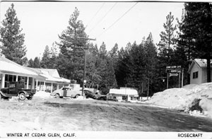 |
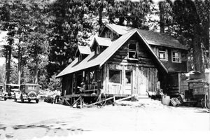
Cedar Glen. Cedar Glen is located on the east shores of Lake Arrowhead. It had its beginning in 1916 when John Suvurkrup subdivided a tract and began selling lots that faced beautiful Little Bear Lake for $150. John had owned and operated a saw mill there in the 1880�s. | |
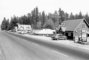 |
Rimforest. Pictured here is a view of the small community of Rimforest located on State Highway 18 between Arrowhead Highlands and Rim High School. Before 1929, the area was known as Redwood Springs Ranch. | |
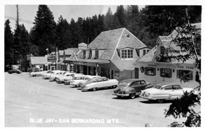 |
Blue Jay. Shown here is the main street through Blue Jay (State Highway 189) in the mid 1950�s. This small community is located near the shores of Lake Arrowhead. The community features our only local theaters and was named for the abundant Stellar Jays, called �Blue Jays�. | |
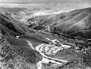 |
Waterman Canyon. The photo shows State Highway 18 in Waterman Canyon when it was only two lanes and the development of homes in the Canyon had not yet been started. Even the development of San Bernardino, in the distance, still shows large areas of open spaces. The image dates to the late 1940�s or early 1950�s. | |
 Home
Home