

Representing
the West-End
of the
San Bernardino Mountains from Crestline
to
Running
Springs
the West-End
of the
San Bernardino Mountains from Crestline
to
Running
Springs
Below
are photographs of Rim of the World Highway
from various points in time
These images and captions can not be reproduced without written
permission from the Rim of the World Historical Society
from various points in time
These images and captions can not be reproduced without written
permission from the Rim of the World Historical Society
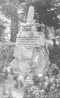
The
Monument
This monument resides on Highway 18 between Arrowhead Highlands and Rim Forest. It commemorates the completion (in 1915) of the 101 mile drive; originally from San Bernardino to Skyland (Crestline), Little Bear Lake (Lake Arrowhead), Green Valley, Fawnskin, Big Bear, Redlands and back to San Bernardino. At that time, it was the longest mountain road in the world.
This monument resides on Highway 18 between Arrowhead Highlands and Rim Forest. It commemorates the completion (in 1915) of the 101 mile drive; originally from San Bernardino to Skyland (Crestline), Little Bear Lake (Lake Arrowhead), Green Valley, Fawnskin, Big Bear, Redlands and back to San Bernardino. At that time, it was the longest mountain road in the world.

Get the new book
by W. Lee Cozad
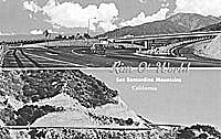
Highway 18 and 138
These two scenes depict the new multi-million dollar over-pass where the Crestline Highway branches off from the famous Rim O' World Highway. This was new in the 1960's.
These two scenes depict the new multi-million dollar over-pass where the Crestline Highway branches off from the famous Rim O' World Highway. This was new in the 1960's.
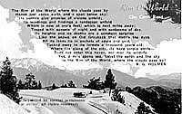
Rim of the World
Highway
This view depicts the poem that a B. G. Holmes wrote about our wonderful mountain highway. Anyone knowing anything about the poem or Mr. Holmes is encouraged to contact us.
This view depicts the poem that a B. G. Holmes wrote about our wonderful mountain highway. Anyone knowing anything about the poem or Mr. Holmes is encouraged to contact us.
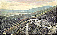
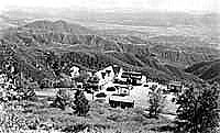
Panorama Point
This is a very early view of what is now Panorama Point. The combination of a spectacular view and the location immediately before the 'switchbacks', lent itself to a resting spot for food and gas.
This is a very early view of what is now Panorama Point. The combination of a spectacular view and the location immediately before the 'switchbacks', lent itself to a resting spot for food and gas.
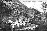
Mountain travel
in another time
This very early view of mountain travel probably pre-dates the Rim of the World Drive. A trip of this nature could take the better part of a day, and now we make it in under 15 minutes.
This very early view of mountain travel probably pre-dates the Rim of the World Drive. A trip of this nature could take the better part of a day, and now we make it in under 15 minutes.

High Gear Road
Now Highway 18 and the Rim of the World Drive. This circa 1940's view depicts the wonderful stone pillars that once marked this historic and scenic roadway. This name (High Gear Road) reflects a major widening and straightening that occurred in the early 1930's.
Now Highway 18 and the Rim of the World Drive. This circa 1940's view depicts the wonderful stone pillars that once marked this historic and scenic roadway. This name (High Gear Road) reflects a major widening and straightening that occurred in the early 1930's.
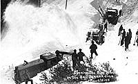
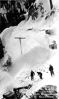
Snow Removal
These views depict earlier efforts to clear our highways in the 1930's and 1940's. It has been awhile since we have seen snow falls of this magnitude - maybe this year.
These views depict earlier efforts to clear our highways in the 1930's and 1940's. It has been awhile since we have seen snow falls of this magnitude - maybe this year.
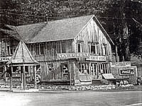
High Gear Garage
Now long gone, but located just up Highway 18 on a now vacant piece of land on the west of the highway. Served mountain travelers from the 30's until the 60's. Is it true that wild animals were once chained outside at this location?
Now long gone, but located just up Highway 18 on a now vacant piece of land on the west of the highway. Served mountain travelers from the 30's until the 60's. Is it true that wild animals were once chained outside at this location?
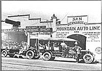
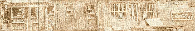
The Mountain Auto
Line -
San Bernardino
Depicted here is the "Stage" depot in San Bernardino where mountain travelers boarded the stage for a trip into the San Bernardino Mountains. Stops included Skyland Heights (Crestline), Pine Crest, Little Bear Valley and Big Bear.
San Bernardino
Depicted here is the "Stage" depot in San Bernardino where mountain travelers boarded the stage for a trip into the San Bernardino Mountains. Stops included Skyland Heights (Crestline), Pine Crest, Little Bear Valley and Big Bear.
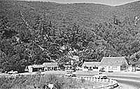
Skyforest
Skyforest first resident was Adam Kuffel. In 1923 Joseph and Mary Henck purchased property in the area, and were the prime movers in the development of this area. Mary was an educator and has a school in the Lake Arrowhead area named for her.
Skyforest first resident was Adam Kuffel. In 1923 Joseph and Mary Henck purchased property in the area, and were the prime movers in the development of this area. Mary was an educator and has a school in the Lake Arrowhead area named for her.
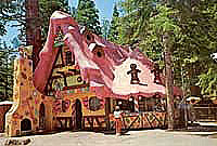
Opened in 1955 (the same year as Disneyland) this family fun park emphasized the Christmas season and kids. J. Putnam Henck (son of Mary and Joseph - see above) managed the 'park' for many years. Now closed.
Now the location of the Cliffhanger Restaurant. Originally the Arrowhead Highlands garage built in the late 1920's. A planned lodge with horseback riding, golf, swimming, etc. never materialized due the economic conditions of the early 1930's.
Copyright © 2006 Rim of the World Historical Society Website design by Entrance Media